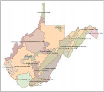
State Wildlife Action Plan, Conservation
Conservation Focus Areas are broad-scale geographic units based on HUC-12 watersheds, used for strategic planning in the West Virginia State Wildlife Action Plan (West Virginia Division of Natural Resources 2015).
HUC-12 watersheds were used to delineate 21 areas of more concentrated conservation focus for West Virginia's State Wildlife Action Plan. Other spatial datasets, such as landscape integrity, were integrated in the delineation process. In the aggregate, the Conservation Focus Areas (CFAs) cover roughly half the state. They vary in size, land ownership, land use, habitat extent, stresses, potential conservation actions, and potential partners (both public and private). The CFAs identification and treatment in the West Virginia SWAP are at the strategic level. Subsequent to United States Fish and Wildlife Service approval of the West Virginia SWAP, the WVDNR are committed to planning and adaptive management at the individual CFA level.
West Virginia Division of Natural Resources, Elkins Operations Center, PO Box 67, Elkins, WV 26241, Ph: (304) 637-0245.
Although these data have been processed successfully on a computer system at the West Virginia Division of Natural Resources, no warranty expressed or implied is made regarding the accuracy or utility of the data on any other system or for general or scientific purposes, nor shall the act of distribution constitute any such warranty. The West Virginia Division of Natural Resources shall not be held liable for improper or incorrect use of the data described and/or contained herein. Please check sources, scale, accuracy, currentness and other available information. Please confirm that you are using the most recent copy of both data and metadata. Acknowledgement of the WVDNR would be appreciated.
ArcGIS Metadata ►
THEMES OR CATEGORIES OF THE RESOURCE biota, environment
PLACE KEYWORDS West Virginia
PLACE KEYWORDS United Sates
PLACE KEYWORDS Northeast United States
THEME KEYWORDS Planning
THEME KEYWORDS State Wildlife Action Plan
THEME KEYWORDS Planning Areas
Hide Topics and Keywords ▲
TITLE Conservation Focus Areas
CREATION DATE 2015-10-30 00:00:00
PUBLICATION DATE 2015-10-30 00:00:00
PRESENTATION FORMATS digital map
FGDC GEOSPATIAL PRESENTATION FORMAT vector digital data
Hide Citation ▲
RESPONSIBLE PARTY
ORGANIZATION'S NAME West Virginia Division of Natural Resources
CONTACT'S ROLE originator
CONTACT INFORMATION ►
PHONE
VOICE (304) 637-0245
FAX (304) 637-0250
ADDRESS
TYPE postal
DELIVERY POINT Elkins Operations Center, PO Box 67
CITY Elkins ADMINISTRATIVE AREA WV POSTAL CODE 26241
HOURS OF SERVICE
M-F, 8:30 AM to 4:30 PM
Hide Contact information ▲
Hide Citation Contacts ▲
DATASET LANGUAGES English (UNITED STATES)
DATASET CHARACTER SET utf8 - 8 bit UCS Transfer Format
STATUS completed
SPATIAL REPRESENTATION TYPE vector
PROCESSING ENVIRONMENT Microsoft Windows 7 Version 6.1 (Build 7601) Service Pack 1; ESRI ArcGIS 10.0.5.4400
CREDITS
West Virginia Division of Natural Resources, Elkins Operations Center, PO Box 67, Elkins, WV 26241, Ph: (304) 637-0245.
Hide Resource Details ▲
EXTENT
DESCRIPTION
Bounding box
GEOGRAPHIC EXTENT
BOUNDING RECTANGLE
EXTENT TYPE Extent used for searching
WEST LONGITUDE -82.703366
EAST LONGITUDE -77.657725
NORTH LATITUDE 40.639804
SOUTH LATITUDE 37.160548
EXTENT CONTAINS THE RESOURCE Yes
TEMPORAL EXTENT
BEGINNING DATE 2015-10-01 00:00:00
Hide Extents ▲
POINT OF CONTACT
ORGANIZATION'S NAME West Virginia Division of Natural Resources
CONTACT'S ROLE author
CONTACT INFORMATION ►
PHONE
VOICE (304) 637-0245
FAX (304) 637-0250
ADDRESS
TYPE postal
DELIVERY POINT Elkins Operations Center, PO Box 67
CITY Elkins ADMINISTRATIVE AREA WV POSTAL CODE 26241
HOURS OF SERVICE
M-F, 8:30 AM to 4:30 PM
Hide Contact information ▲
Hide Resource Points of Contact ▲
RESOURCE MAINTENANCE
UPDATE FREQUENCY as needed
Hide Resource Maintenance ▲
CONSTRAINTS LIMITATIONS OF USE
Although these data have been processed successfully on a computer system at the
West Virginia Division of Natural Resources, no warranty expressed or implied is made regarding the accuracy or utility of the data on any other system or for general or scientific purposes, nor shall the act of distribution constitute any such warranty. The West Virginia Division of Natural Resources shall not be held liable for improper or incorrect use of the data described and/or contained herein. Please check sources, scale, accuracy, currentness and other available information. Please confirm that you are using the most recent copy of both data and metadata. Acknowledgement of the WVDNR would be appreciated.
Hide Resource Constraints ▲
REFERENCE SYSTEM IDENTIFIER VALUE 26917 CODESPACE EPSG VERSION 7.4.1
Hide Spatial Reference ▲
VECTOR ►
LEVEL OF TOPOLOGY FOR THIS DATASET geometry only
GEOMETRIC OBJECTS
OBJECT TYPE composite
OBJECT COUNT 22
Hide Vector ▲
Hide Spatial Data Properties ▲
LINEAGE STATEMENT
HUC-12 watersheds were used to delineate 21 areas of more concentrated conservation focus for West Virginia's State Wildlife Action Plan. Other spatial datasets, such as landscape integrity, were integrated in the delineation process. In the aggregate, the Conservation Focus Areas (CFAs) cover roughly half the state. They vary in size, land ownership, land use, habitat extent, stresses, potential conservation actions, and potential partners (both public and private). The CFAs identification and treatment in the West Virginia SWAP are at the strategic level. Subsequent to United States Fish and Wildlife Service approval of the West Virginia SWAP, the WVDNR are committed to planning and adaptive management at the individual CFA level.
PROCESS STEP ►
WHEN THE PROCESS OCCURRED 2015-07-01 00:00:00
DESCRIPTION
HUC-12 watersheds were used to delineate 21 areas of more concentrated conservation focus
PROCESS CONTACT
ORGANIZATION'S NAME West Virginia Division of Natural Resources
CONTACT'S ROLE originator
CONTACT INFORMATION ▼
Hide Process step ▲
PROCESS STEP ►
WHEN THE PROCESS OCCURRED 2016-10-03 00:00:00
DESCRIPTION
Slivergons (very small edge polygons) were dissolved
PROCESS CONTACT
ORGANIZATION'S NAME West Virginia Division of Natural Resources
CONTACT'S ROLE originator
CONTACT INFORMATION ▼
Hide Process step ▲
PROCESS STEP ►
WHEN THE PROCESS OCCURRED 2016-10-03 00:00:00
DESCRIPTION
Some small polygons on the boundary were re-attributed to be part of the larger adjacent CFA
PROCESS CONTACT
ORGANIZATION'S NAME West Virginia Division of Natural Resources
CONTACT'S ROLE originator
CONTACT INFORMATION ►
PHONE
VOICE (304) 637-0245
FAX (304) 637-0250
ADDRESS
TYPE postal
DELIVERY POINT Elkins Operations Center, PO Box 67
CITY Elkins ADMINISTRATIVE AREA WV POSTAL CODE 26241
HOURS OF SERVICE
M-F, 8:30 AM to 4:30 PM
Hide Contact information ▲
Hide Process step ▲
PROCESS STEP ►
WHEN THE PROCESS OCCURRED 2016-10-03 00:00:00
DESCRIPTION
Polygons were clipped to the WV state boundary
PROCESS CONTACT
ORGANIZATION'S NAME West Virginia Division of Natural Resources
CONTACT'S ROLE originator
CONTACT INFORMATION ►
PHONE
VOICE (304) 637-0245
FAX (304) 637-0250
ADDRESS
TYPE postal
DELIVERY POINT Elkins Operations Center, PO Box 67
CITY Elkins ADMINISTRATIVE AREA WV POSTAL CODE 26241
HOURS OF SERVICE
M-F, 8:30 AM to 4:30 PM
Hide Contact information ▲
Hide Process step ▲
Hide Lineage ▲
DISTRIBUTION FORMAT
NAME File Geodatabase Feature Dataset
TRANSFER OPTIONS
TRANSFER SIZE 0.000
Hide Distribution ▲
DETAILS FOR OBJECT conservation_focus_areas ►
FIELD OBJECTID ►
DATA TYPE ObjectID
WIDTH N/A
FIELD DESCRIPTION
Internal feature number.
DESCRIPTION SOURCE
ESRI
DESCRIPTION OF VALUES
Sequential unique whole numbers that are automatically generated.
Hide Field OBJECTID ▲
FIELD Shape ►
DATA TYPE Geometry
WIDTH N/A
FIELD DESCRIPTION
Feature geometry.
DESCRIPTION SOURCE
ESRI
DESCRIPTION OF VALUES
Coordinates defining the features.
Hide Field Shape ▲
FIELD CFA_Name ► DATA TYPE Text WIDTH 50
FIELD DESCRIPTION
Name of the Conservation Focus Area based on river, mountain, valley, or geopraphic place name.
DESCRIPTION SOURCE
WVDNR
Hide Field CFA_Name ▲
FIELD CFA_ID ►
DATA TYPE Short Integer
WIDTH N/A
FIELD DESCRIPTION
Identification number
DESCRIPTION SOURCE
WVDNR
Hide Field CFA_ID ▲
FIELD Acres ►
DATA TYPE Double
WIDTH N/A
FIELD DESCRIPTION
Acres calculated from geometry
DESCRIPTION SOURCE
WVDNR
Hide Field Acres ▲
FIELD Shape_Length ► DATA TYPE Double WIDTH N/A
FIELD DESCRIPTION
Length of feature in internal units.
DESCRIPTION SOURCE
ESRI
DESCRIPTION OF VALUES
Positive real numbers that are automatically generated.
Hide Field Shape_Length ▲
FIELD Shape_Area ►
DATA TYPE Double
WIDTH N/A
FIELD DESCRIPTION
Area of feature in internal units squared.
DESCRIPTION SOURCE
ESRI
DESCRIPTION OF VALUES
Positive real numbers that are automatically generated.
Hide Field Shape_Area ▲
FIELD Label ►
DATA TYPE Text
WIDTH 50
FIELD DESCRIPTION
CFA_ID and CFA_Name combined for labeling
DESCRIPTION SOURCE
WVDNR
Hide Field Label ▲
Hide Details for object conservation_focus_areas ▲
Hide Fields ▲
METADATA LANGUAGE English (UNITED STATES)
METADATA CHARACTER SET utf8 - 8 bit UCS Transfer Format
SCOPE OF THE DATA DESCRIBED BY THE METADATA dataset
SCOPE NAME dataset
LAST UPDATE 2016-09-29
ARCGIS METADATA PROPERTIES
METADATA FORMAT ArcGIS 1.0
STANDARD OR PROFILE USED TO EDIT METADATA FGDC
Hide Metadata Details ▲
METADATA CONTACT
ORGANIZATION'S NAME West Virginia Division of Natural Resources
CONTACT'S ROLE author
CONTACT INFORMATION ►
PHONE
VOICE (304) 637-0245
FAX (304) 637-0250
ADDRESS
TYPE postal
DELIVERY POINT Elkins Operations Center, PO Box 67
CITY Elkins ADMINISTRATIVE AREA WV POSTAL CODE 26241
HOURS OF SERVICE
M-F, 8:30 AM to 4:30 PM
Hide Contact information ▲
Hide Metadata Contacts ▲
MAINTENANCE
UPDATE FREQUENCY as needed
Hide Metadata Maintenance ▲
THUMBNAIL
THUMBNAIL TYPE JPG
Hide Thumbnail and Enclosures ▲