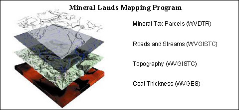
Established in 1995, West Virginia's Mineral Lands Mapping Program (MLMP) is a multi-agency, cooperative effort working to evaluate and quantify coal mineral properties for property tax purposes. The MLMP utilizes Geographic Information Systems (GIS) to model coal-bearing lands throughout West Virginia for natural resource assessment. The Property Tax Division's Mineral Parcel Mapping Project (MPMP) reconciles and attributes mineral parcel records and maps. The Geological and Economic Survey's Coal Bed Mapping Project (CBMP) delineates, correlates, and maps coal seams. The WVGISTC's Digital Line Graph (DLG) Conversion Project produces planimetric and elevation vectors from USGS 7.5-minute topographic base maps.